Map of Kaspiysk
Detailed interactive map of Kaspiysk. Map of Kaspiysk with streets and numbers of houses. Satellite map of Kaspiysk with sights of the city.
The change between the satellite map of Kaspiysk and the schematic one is made in the lower left corner of the interactive map.
Kaspiysk
The population of the city Kaspiysk: 128,663 people (2021)
Date of foundation of Kaspiysk: 1932
The telephone code of the city Kaspiysk: +7 87246
The automobile code of the city Kaspiysk: 5
Postal code of the city Kaspiysk: 368300
Kaspiysk is a coastal city near the Caspian Sea, to which it owes its name. It belongs to the territory of Dagestan, and is only 14 km away. It is separated from Makhachkala. Today, Kaspiysk is known both as an industrial city and as a fairly visited Caspian resort, because it has a very favorable climate.
The economy of Kaspiysk is represented by machine-building enterprises. Trains run from the Kaspiysk railway station to Makhachkala, Izberbash, Dagestan Lights, Derbent, Kizilyurt, Khasavyurt.
What to see in Kaspiysk
Many people note the St. Petersburg features that can be traced in the architecture and atmosphere of the town. This is not surprising, because the architects from St. Petersburg were engaged in the design of Kaspiysk.
The main attraction is the Seaside Park, which is unique because of the extensive Caucasian vegetation collected on its territory. The religious life of the city is also very intense, but there are practically no Orthodox churches in Kaspiysk, because most of the inhabitants profess Islam.
Sights of Kaspiysk
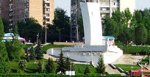
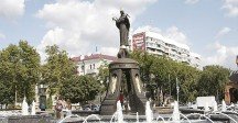
Khalilov Park, Obelisk-monument to the "Grieving Mother", Monument to Alexander Nazarov.
The largest cities in Russia:
2024 © Russia-Karta.ru
